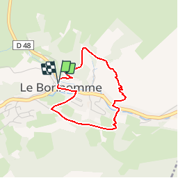
11.9 km | 16.6 km-effort
Le Bonhomme - Circuit du village
Desrumaux
User GUIDE
Length
3 km
Max alt
774 m
Uphill gradient
174 m
Km-Effort
5.3 km
Min alt
670 m
Downhill gradient
179 m
Boucle
Yes
Creation date :
2014-12-10 00:00:00.0
Updated on :
2014-12-10 00:00:00.0
1h30
Difficulty : Easy
FREE GPS app for hiking
About
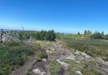
Trail Walking of 3 km to be discovered at Grand Est, Haut-Rhin, Le Bonhomme. This trail is proposed by Desrumaux.
Description
Détails de la rando sur TraceGPS.com http://www.tracegps.com/fr/parcours/circuit11228.htm
Positioning
Country:
France
Region :
Grand Est
Department/Province :
Haut-Rhin
Municipality :
Le Bonhomme
Location:
Unknown
Start:(Dec)
Start:(UTM)
359768 ; 5337232 (32U) N.
Comments
Trails nearby
2012-06-16 Marche aux Alisiers Orbey
Walking
Easy
(2)
Lapoutroie,
Grand Est,
Haut-Rhin,
France
11.1 km | 16.6 km-effort
2h 49min
Yes
Lac Blanc - Têtes des Faux
Mountain bike
Medium
(1)
Orbey,
Grand Est,
Haut-Rhin,
France
15.3 km | 21 km-effort
1h 0min
Yes
2021-02-14 Marche Bagenelles Brezouard Fuste de Etoile
Walking
Very difficult
Sainte-Marie-aux-Mines,
Grand Est,
Haut-Rhin,
France
17.1 km | 27 km-effort
6h 6min
Yes
2020-07-19 Marche Étang du Devin Col Calvaire Tête des Faux
Walking
Very easy
Lapoutroie,
Grand Est,
Haut-Rhin,
France
14.2 km | 22 km-effort
3h 27min
Yes
CVL - Rando 25/03/2024 - Col de Chamont
Walking
Medium
Fréland,
Grand Est,
Haut-Rhin,
France
6.6 km | 9.5 km-effort
2h 15min
Yes
Lac blanc col du calvaire
Walking
Le Bonhomme,
Grand Est,
Haut-Rhin,
France
5 km | 7.2 km-effort
2h 13min
Yes
Le Haïcot - Le Petit Brézouard - Le Haïcot
On foot
Easy
(2)
Sainte-Marie-aux-Mines,
Grand Est,
Haut-Rhin,
France
7.1 km | 10.5 km-effort
2h 23min
Yes
rdpr G3 le bonhomme 230905
Walking
Difficult
Lapoutroie,
Grand Est,
Haut-Rhin,
France
11.6 km | 16.5 km-effort
4h 12min
Yes